| Fasttrack
to America's Past Teacher Key |
|
| Fasttrack
to America's Past Teacher Key |
|
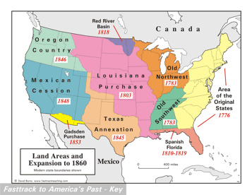
 Page 104  Page 105 The map is shown
as it appears when completed by students using color
pencils. The
full size map that students will use to guide their work can be found
with the link on the main index page for this section.
Please read the "Tips for completing the map" in the next column. |
Pages 104
& 105 - Map - Land Areas and Expansion to 1860 Map guide, page 104 Students should use the word bank at the bottom of the page as they work to complete the map guide's "fill in the blank" sentences. Area of the Original States - ...13 colonies... Old Southwest - ...Daniel Boone helped... Old Northwest - ...to buy land... Florida - ...was Spanish territory... Louisiana Purchase - ...from France. Red River Basin - ...between Canada and... Texas Annexation - ...from Mexico. Oregon Country - ...and Clark in... Mexican Cession - ...a payment of... Gadsden Purchase - ...for a railroad. The picture The Alamo, in San Antonio, Texas. The old mission fort was the scene of a famous battle between Texans and the Mexican army in 1836. Tips for completing the map, page 105 Students should
work from the full size, completed map page shown with the link from
this
section's main
index page.
Emphasize neatness from the beginning! This map shows the major pieces of land that made up the United States in 1860. Remind students to shade very lightly, or the labels will be hard to read. Also remind them to leave a "window" as shown in the large areas, so the dates show through clearly. The dates are listed in the paragraphs on the facing map guide page. Labeling should be done with a regular #2 pencil, or an erasable ink pen. Regular color pencils are not very good for small lettering, and a mistake with a regular ink pen can't be corrected. |
|
Copyright Notice
Copyright 2018 by David Burns. All rights reserved. Illustrations and reading selections appearing in this work are taken from sources in the public domain and from private collections used by permission. Sources include: the Dover Pictorial Archive, the Library of Congress, The National Archives, The Hart Publishing Co., Corel Corporation and its licensors, Nova Development Corporation and its licensors, and others. Maps were created or adapted by the author using reference maps from the United States Geological Survey and Cartesia Software. Please see the home page for this title for more information. |