 |
Fasttrack
to America's Past Teacher Key |
|
|
Fasttrack
to America's Past Teacher Key |
|
 Page 216 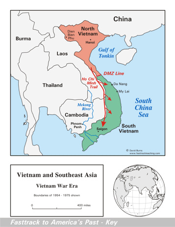 Page 217 The map is shown
as it appears when it is completed by students using color
pencils. The
full size map that students will use to guide their work can be found
with the link on the main index page for this section.
Please read the "Tips for completing the map" in the next column. |
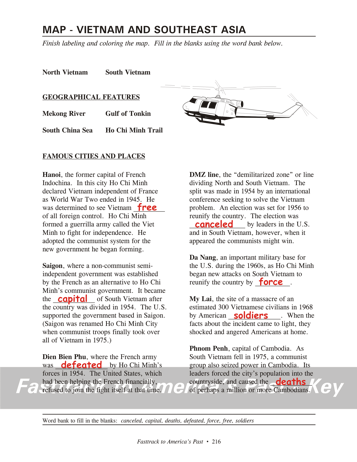
Pages 216
& 217 - Map - Vietnam and Southeast Asia Map guide, page 216 Students should use the word bank at the bottom of the page as they work to complete the map guide's "fill in the blank" sentences. Hanoi - ...Vietnam free of... Saigon - ...the capital of... Dien Bien Phu - ...was defeated by... DMZ line - ...was canceled by... Da Nang - ...country by force. My Lai - ...by American soldiers. Phnom Penh - ...the deaths of... The picture A helicopter like those used to support American troops in Vietnam. The geography of Vietnam made the helicopter vital for moving soldiers quickly to and from battle areas. Tips for completing the map, page 217 Students should
work from the full size, completed map page shown with the link from
this
section's main
index page.
Emphasize neatness from the beginning! Ask students to color and label the Mekong
River first. Remind them to use a #2 pencil or an erasable ink
pen for labeling the bodies of
water - color pencils are not very good for lettering. Next, ask students to draw the Ho Chi Minh Trail in red. It is named for one of the North Vietnamese leaders. Communist forces used this trail - actually a network of trails - to move soldiers and weapons into South Vietnam. Students should color North and South
Vietnam very lightly,
so the labels are not obscured. The DMZ line should be in red or
orange. Today, of course, there is only one Vietnam, and it is
under
the control of that country's Communist Party leaders. Saigon was
renamed Ho Chi Minh City after the communist take-over of South Vietnam
in 1975. Finally, students should label and lightly shade the water areas in light blue. |
|
Copyright Notice
Copyright 2018 by David Burns. All rights reserved. Illustrations and reading selections appearing in this work are taken from sources in the public domain and from private collections used by permission. Sources include: the Dover Pictorial Archive, the Library of Congress, The National Archives, The Hart Publishing Co., Corel Corporation and its licensors, Nova Development Corporation and its licensors, and others. Maps were created or adapted by the author using reference maps from the United States Geological Survey and Cartesia Software. Please see the home page for this title for more information. |