 |
Fasttrack
to America's Past Teacher Key |
|
|
Fasttrack
to America's Past Teacher Key |
|
 Page 210 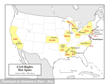 Page 211 The map is shown
as it appears when it is completed by students using color
pencils. The
full size map that students will use to guide their work can be found
with the link on the main index page for this section.
Please read the "Tips for completing the map" in the next column. |
Pages 210
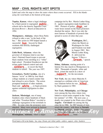
& 211 - Map - Civil Rights Hot Spots Map guide, page 210 Students should use the word bank at the bottom of the page as they work to complete the map guide's "fill in the blank" sentences. Topeka - ...segregated public schools... Montgomery - ...successful bus boycott... Little Rock - ...set soldiers to escort... Greensboro - ...and white, to begin protests... Jackson - ...summer in jail. Birmingham - ...police dogs and water hoses... Washington - "I Have a Dream" speech. Selma - ...of support for the movement. New York - ...was killed by black gunmen... New York, Philadelphia, and Chicago - ...not just a Southern issue. The picture Rev. Martin Luther King, Jr. He wanted America to move peacefully past racism and segregation, and insisted that non-violence was the best approach to change. Sadly, deep set racial prejudices and anger over past wrongs sometimes led to violence from both sides of the racial divide. Rev. King was assassinated in 1968 during a visit to Memphis in support of a strike by that city's garbage workers. Tips for completing the map, page 211 Students should
work from the full size, completed map page shown with the link from
this
section's main
index page.
Emphasize neatness from the beginning! Ask students to label the states highlighted on the map first. Have them use a #2 pencil or an erasable ink pen - color pencils do not work very well for small lettering. Be sure to point out that Michigan spans two areas of land. Next, have students shade the states highlighted on the map lightly with a yellow color pencil. As you review the main events of the Civil Rights movement, be sure to have students to refer to the map frequently. Many students are very fuzzy about states and cities outside their own region. |
|
Copyright Notice
Copyright 2018 by David Burns. All rights reserved. Illustrations and reading selections appearing in this work are taken from sources in the public domain and from private collections used by permission. Sources include: the Dover Pictorial Archive, the Library of Congress, The National Archives, The Hart Publishing Co., Corel Corporation and its licensors, Nova Development Corporation and its licensors, and others. Maps were created or adapted by the author using reference maps from the United States Geological Survey and Cartesia Software. Please see the home page for this title for more information. |