 |
Fasttrack
to America's Past Teacher Key |
|
|
Fasttrack
to America's Past Teacher Key |
|
 Page 206 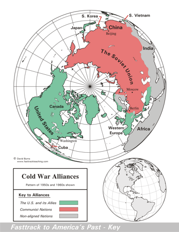 Page 207 The map is shown
as it appears when it is completed by students using color
pencils. The
full size map that students will use to guide their work can be found
with the link on the main index page for this section.
Please read the "Tips for completing the map" in the next column. |
Pages 206
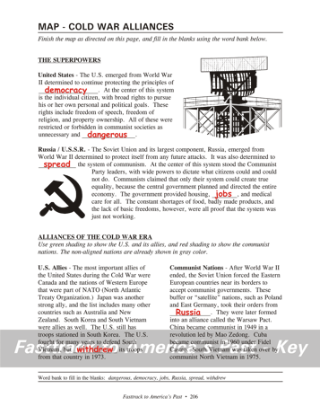
& 208 - Map - Cold War Alliances Map guide, page 206 Students should use the word bank at the bottom of the page as they work to complete the map guide's "fill in the blank" sentences. United States - ...the principles of democracy. ...as unnecessary and dangerous. Russia /U.S.S.R. - ...determined to spread the system of communism. ...provided housing, jobs, and medical care for all. U.S. Allies - ...but withdrew its troops... Communist Nations - ...orders from Russia. The pictures 1. A radar antenna mounted on a tower. The United States built a string of radar stations along a line from Alaska to Greenland to warn of any bomber or missile attack by the Soviet Union. Any attack on America from the U.S.S.R. would have come "over the Pole," since that is the shortest route from the Soviet Union to the United States. 2. The "Hammer and Sickle" symbol of communism. The hammer represents industry and the sickle represents agriculture. In the communist system, both are controlled by the government. Tips for completing the map, page 207 Students should
work from the full size, completed map page shown with the link from
this
section's main
index page.
Emphasize neatness from the beginning! This type of map is called a North Polar Projection map, because it is centered on the North Pole. It is an especially good type of projection for this topic, since it clearly shows the two groups of nations that faced off against each other in the Cold War. Have students shade the communist nations in red. Remind them to color lightly! Point out Cuba, which is just off the coast of Florida.Have students carefully color the U.S. and its allies with green. Point out South Korea and South Vietnam, which are labeled on the map. Remind them that North Korea and North Vietnam on this type of map are not "up" on the page from South Korea and South Vietnam, but "in" toward the center of the map. Students should leave the non-aligned nations shown on the map as they are - shaded gray. Remind them to add the correct colors on the key as needed. |
|
Copyright Notice
Copyright 2018 by David Burns. All rights reserved. Illustrations and reading selections appearing in this work are taken from sources in the public domain and from private collections used by permission. Sources include: the Dover Pictorial Archive, the Library of Congress, The National Archives, The Hart Publishing Co., Corel Corporation and its licensors, Nova Development Corporation and its licensors, and others. Maps were created or adapted by the author using reference maps from the United States Geological Survey and Cartesia Software. Please see the home page for this title for more information. |