 |
Fasttrack
to America's Past Teacher Key |
|
|
Fasttrack
to America's Past Teacher Key |
|
 Page 192 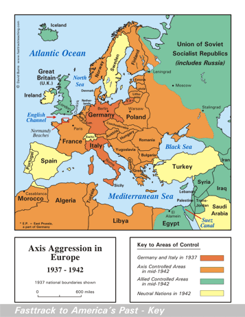 Page 193 The map is shown
as it appears when it is completed by students using color
pencils. The
full size map that students will use to guide their work can be found
with the link on the main index page for this section.
Please read the "Tips for completing the map" in the next column. |
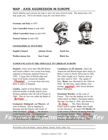
Pages 192
& 193 - Map - Axis Aggression in Europe Map guide, page 192 Students should use the word bank at the bottom of the page as they work to complete the map guide's "fill in the blank" sentences. Dunkirk - ...English Channel to... London - ...Battle of Britain. Leningrad - ...helped stop the advance... Casablanca - ...turning against their... Normandy Beaches - ...known as D-Day. ...Hitler shot himself... The pictures 1. Adolf Hitler, the Nazi Party leader who ruled Germany during World War Two. He committed suicide in the German capital, Berlin, as that city fell to advancing Russian troops in 1945. 2. Benito Mussolini, the Fascist Party leader who ruled Italy during World War Two. Near the end of the war, he was shot by Italians who opposed his dictatorship. Tips for completing the map, page 193 Students should
work from the full size, completed map page shown with the link from
this
section's main
index page.
Emphasize neatness from the beginning! It's a good idea to have students color Germany and Italy first, using a red color pencil. Remind students to shade the land areas very lightly, so the labels and borders will not be obscured. Then have students do the areas conquered by the Axis powers, using orange. The dotted line will help students place the shading correctly in Russia and North Africa. Next, students can color the areas controlled by the Allies in mid-1942, and the neutral nations. Be sure to point out Dunkirk and the Normandy Beaches in France, and the Suez Canal in Egypt. All played important roles in the war. The Atlantic Ocean and the seas can be done
last in light
blue. Use a #2 pencil for labeling them, or an erasable ink pen,
since color pencils don't
do lettering very well. Remind students to check that they put
the correct colors in the map key. |
|
Copyright Notice
Copyright 2018 by David Burns. All rights reserved. Illustrations and reading selections appearing in this work are taken from sources in the public domain and from private collections used by permission. Sources include: the Dover Pictorial Archive, the Library of Congress, The National Archives, The Hart Publishing Co., Corel Corporation and its licensors, Nova Development Corporation and its licensors, and others. Maps were created or adapted by the author using reference maps from the United States Geological Survey and Cartesia Software. Please see the home page for this title for more information. |