 |
Fasttrack
to America's Past Teacher Key |
|
|
Fasttrack
to America's Past Teacher Key |
|
 Page 174 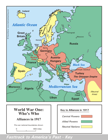 Page 175 The map is shown
as it appears when it is completed by students using color
pencils. The
full size map that students will use to guide their work can be found
with the link on the main index page for this section.
Please read the "Tips for completing the map" in the next column. |
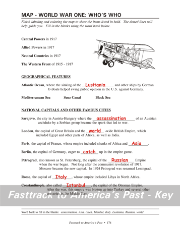
Pages 174
& 175 - Map - World War One: Who's Who Map guide, page 174 Students should use the word bank at the bottom of the page as they work to complete the map guide's "fill in the blank" sentences. Atlantic Ocean - ...the Lusitania and... Sarajevo - ...the assassination of... London - ...the world-wide... Paris - ...Africa and Asia. Berlin - ...to catch up... Petrograd - ...the Russian Empire... Rome - ...of Italy, whose... Constantinople - ...called Istanbul, the... The picture A biplane of the type used in World War One. The construction was typically a lightweight frame covered with fabric. Tips for completing the map, page 175 Students should
work from the full size, completed map page shown with the link from
this
section's main
index page.
Emphasize neatness from the beginning! It's a good idea to have students color the Western Front first, using a red color pencil. A dotted line in France shows the location. Also point out the Suez Canal. Students should color it with a blue pencil. A dotted line in Egypt shows the location. Remind students to shade the land areas very
lightly, so
the labels and borders will not be obscured. Note that the map
does
not show the areas conquered, but only who was on which side. |
|
Copyright Notice
Copyright 2018 by David Burns. All rights reserved. Illustrations and reading selections appearing in this work are taken from sources in the public domain and from private collections used by permission. Sources include: the Dover Pictorial Archive, the Library of Congress, The National Archives, The Hart Publishing Co., Corel Corporation and its licensors, Nova Development Corporation and its licensors, and others. Maps were created or adapted by the author using reference maps from the United States Geological Survey and Cartesia Software. Please see the home page for this title for more information. |