 |
Fasttrack
to America's Past Teacher Key |
|
|
Fasttrack
to America's Past Teacher Key |
|
 Page 173 |
Page 173 -
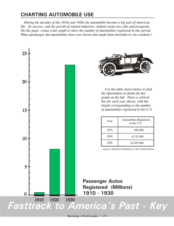
Charting Automobile Use Making the chart Students will need just one color pencil for this bar graph. Green is a good choice. Remind students that the figure for 1910 is less than one million, so the first bar will be very short. What the chart shows This chart shows the very rapid growth in the number of automobiles in the U.S. from 1910 to 1930. Notice that the graph is not showing yearly sales, but the number of cars registered.
The rapid growth was possible because the price of cars like the Ford
Model
T was actually falling. Large scale production and the
development
of the moving assembly line were the key reasons for this. Background
for the chart
question The automobile had many advantages over horses for city residents in the early 1900s. A horse needs daily attention and grooming. It must be fed and exercised whether it is used for a trip or not. As any stable boy knew only too well, the job of cleaning up after a horse is no fun at all. City streets, too, were fouled by horses. An automobile needs gas only when it is used. It can stay garaged without care for weeks or months. Although it produces some pollution, this was not nearly as bad as the problem left by horses on city streets. In economic terms, the automobile had much lower operating costs and gave most owners more benefits than horses. |
|
Copyright Notice
Copyright 2018 by David Burns. All rights reserved. Illustrations and reading selections appearing in this work are taken from sources in the public domain and from private collections used by permission. Sources include: the Dover Pictorial Archive, the Library of Congress, The National Archives, The Hart Publishing Co., Corel Corporation and its licensors, Nova Development Corporation and its licensors, and others. Maps were created or adapted by the author using reference maps from the United States Geological Survey and Cartesia Software. Please see the home page for this title for more information. |