 |
Fasttrack
to America's Past Teacher Key |
|
|
Fasttrack
to America's Past Teacher Key |
|
 Page 150 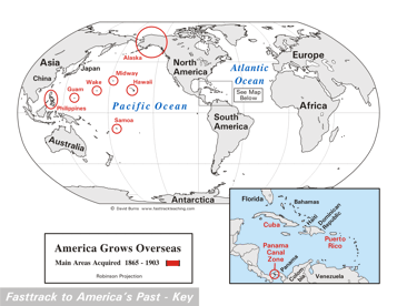 Page 151 The map is shown
as it appears when completed by students using color
pencils. The
full size map that students will use to guide their work can be found
with the link on the main index page for this section.
Please read the "Tips for completing the map" in the next column. |
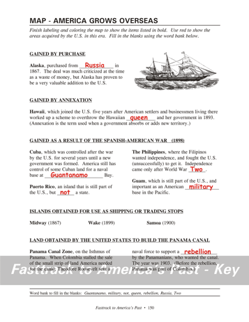
Pages 150
& 151 - Map - America Grows Overseas Map guide, page 150 Students should use the word bank at the bottom of the page as they work to complete the map guide's "fill in the blank" sentences. Alaska - ...from Russia in... Hawaii - ...Hawaiian Queen and... Cuba - ...at Guantanamo Bay. Puerto Rico - ...but not a state. The Philippines - ...World War Two. Guam - ...American military base... Panama Canal Zone - ...a rebellion by... The picture An ocean-going ship designed to use both sails and steam engines. Steamships became much more common than sailing ships on the ocean by 1900 because they were faster and more reliable. Tips for completing the map, page 151 Students should
work from the full size, completed map page shown with the link from
this
section's main
index page.
Emphasize neatness from the beginning! Students should use a red color pencil for the highlight circles. For labeling the places and the oceans, it is best to use a #2 pencil or erasable ink pens, however, because color pencils are not very good for small lettering. Remind students to add color to the map key. A blue color pencil is needed to mark the
line of the Panama
Canal Zone in the inset map. Use light blue to
color the water in the inset map. It is best not to color the
oceans on the world map. The Panama Canal Zone was returned to the
government
of Panama in 1999, as a result of a treaty signed by President Jimmy
Carter in 1977. |
|
Copyright Notice
Copyright 2018 by David Burns. All rights reserved. Illustrations and reading selections appearing in this work are taken from sources in the public domain and from private collections used by permission. Sources include: the Dover Pictorial Archive, the Library of Congress, The National Archives, The Hart Publishing Co., Corel Corporation and its licensors, Nova Development Corporation and its licensors, and others. Maps were created or adapted by the author using reference maps from the United States Geological Survey and Cartesia Software. Please see the home page for this title for more information. |