 |
Fasttrack
to America's Past Teacher Key |
|
|
Fasttrack
to America's Past Teacher Key |
|
 Page 148 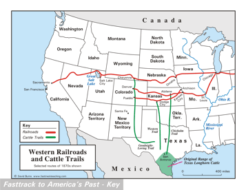 Page 149 The map is shown
as it appears when completed by students using color
pencils. The
full size map that students will use to guide their work can be found
with the link on the main index page for this section.
Please read the "Tips for completing the map" in the next column. |
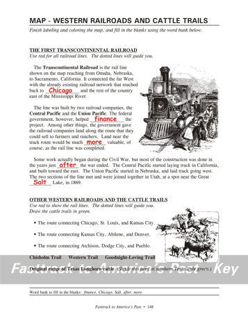
Pages 148
& 149 - Map - Western Railroads and Cattle Trails Map guide, page 148 Students should use the word bank at the bottom of the page as they work to complete the map guide's "fill in the blank" sentences. Paragraph 1 - ...back to Chicago and the rest of... Paragraph 2 - ...government, however, helped finance the project... would be much more valuable, of course... Paragraph 3 - ...the years just after the... at a spot near the Great Salt Lake, in 1869. The pictures 1. Trains like this, and the spread of railroad tracks into the West, helped make possible the spread of settlers and farms in the Great Plains. 2. Cowboys rounding up cattle in Texas, to get ready to move the full grown animals up a cattle trail to one of the "cow towns" built along the rail lines. The railroads would take the cattle to Chicago and other cities, where they were sold to meat packing companies, slaughtered, and the meat cut up for sale. Tips for completing the map, page 149 Students should
work from the full size, completed map page shown with the link from
this
section's main
index page.
Emphasize neatness from the beginning! Have students complete the rivers first,
using a blue
color pencil, then the Great Lakes and the Great Salt Lake, using
a light
blue pencil. That will help orient them to the geographical
features on the map. Tell students to use green color pencils to
show the cattle trails and the original
range of the Texas Longhorn. The labels are already on the
map.
Point out that the cattle trails all end at towns along one of the
railroad lines.
There were other cattle trails as well, but these are three of the most
famous. Finally, remind students to complete the
colors in the map's key, and to finish the job by coloring the Pacific
Ocean and Gulf of Mexico with light blue pencil. |
|
Copyright Notice
Copyright 2018 by David Burns. All rights reserved. Illustrations and reading selections appearing in this work are taken from sources in the public domain and from private collections used by permission. Sources include: the Dover Pictorial Archive, the Library of Congress, The National Archives, The Hart Publishing Co., Corel Corporation and its licensors, Nova Development Corporation and its licensors, and others. Maps were created or adapted by the author using reference maps from the United States Geological Survey and Cartesia Software. Please see the home page for this title for more information. |