 |
Fasttrack
to America's Past Teacher Key |
|
|
Fasttrack
to America's Past Teacher Key |
|
 Page 134 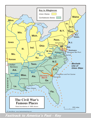 Page 135 The map is shown
as it appears when completed by students using color
pencils. The
full size map that students will use to guide their work can be found
with the link on the main index page for this section.
Please read the "Tips for completing the map" in the next column. |
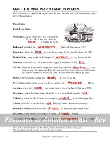
Pages 134
& 135 - Map - The Civil War's Famous Places Map guide, page 134 Students should use the word bank at the bottom of the page as they work to complete the map guide's "fill in the blank" sentences. Washington - ...the Union or... Richmond - ...the Confederate States... Charleston - ...the first shots... Blockade Line - ...placed warships to... Manassas - ...of Bull Run. Norfolk - ...the Merrimac as... Shiloh - ...how deadly the... New Orleans - ...the Mississippi River. Antietam - ...the South was... Gettysburg - ...again in 1863. Vicksburg - ...complete control of... Atlanta - ...in 1864, helping... Sherman's March - ...from Atlanta to... Savannah - ...on the Atlantic Ocean... Appomattox Court House - ...finally surrendered in... The picture A soldier stands guard duty next to a Civil War era cannon. Tips for completing the map, page 135 Students should
work from the full size, completed map page shown with the link from
this
section's main
index page.
Emphasize neatness from the beginning! Tell students to complete the map details before
doing
the shading of the states. Use dark blue color pencil for the
rivers, and light blue for the Great Lakes. Be sure students add
the label for Sherman's
March by using either a #2 pencil or an erasable red ink pen.
Color pencils do not do very well with small lettering, and a mistake
made with a regular ink pen can't be corrected. The Atlantic
Ocean and Gulf of Mexico should be shaded light blue as the last step. Remind students that there were hundreds of battles during the years of the Civil War. It would take a very large and very detailed map to show them all. |
|
Copyright Notice
Copyright 2018 by David Burns. All rights reserved. Illustrations and reading selections appearing in this work are taken from sources in the public domain and from private collections used by permission. Sources include: the Dover Pictorial Archive, the Library of Congress, The National Archives, The Hart Publishing Co., Corel Corporation and its licensors, Nova Development Corporation and its licensors, and others. Maps were created or adapted by the author using reference maps from the United States Geological Survey and Cartesia Software. Please see the home page for this title for more information. |