 |
Fasttrack
to America's Past Teacher Key |
|
|
Fasttrack
to America's Past Teacher Key |
|
 Page 108 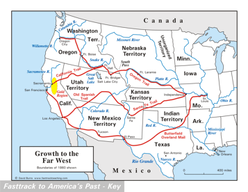 Page 109 The map is shown
as it appears when completed by students using color
pencils. The
full size map that students will use to guide their work can be found
with the link on the main index page for this section.
Please read the "Tips for completing the map" in the next column. |
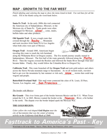
Pages 108
& 109 - Map - Growth to the Far West Map guide, page 108 Students should use the word bank at the bottom of the page as they work to complete the map guide's "fill in the blank" sentences. Santa Fe Trail - ...Mexican silver coins... Old Spanish Trail - ...the Rocky Mountains. Oregon Trail - ...the Platte River... California Trial - ...early snow storms... Butterfield Overland Mail - ...and San Francisco. Rio Grande - ...the Nueces River... The pictures 1. Indian teepees on the Great Plains. These dwellings were made of buffalo hides over wood poles. They could be easily taken apart and carried to new locations. 2. A covered wagon, often called a Conestoga wagon because they were first built in Conestoga, Pennsylvania. The version used to take settlers to the Far West, however, was built smaller and lighter. Tips for completing the map, page 109 Students should
work from the full size, completed map page shown with the link from
this
section's main
index page.
Emphasize neatness from the beginning! This map shows some of the most famous roads that took Americans to the Far West during the first half of the 19th century. Remind students that it does not show all the trails of the period. Students should draw each route lightly at
first,
and check carefully to be sure they have it in the right
position.
Then they can go over the route again to darken the color and make it
more
visible. All of the routes on this map should be drawn with a red
color pencil. It is best to label them with a regular #2 pencil
or an erasable ink pen,
however, since color pencils are not very good for small lettering. Next, have students color the gold region
with a yellow
color pencil. The area is indicated with an oval just east of
Sacramento. |
|
Copyright Notice
Copyright 2018 by David Burns. All rights reserved. Illustrations and reading selections appearing in this work are taken from sources in the public domain and from private collections used by permission. Sources include: the Dover Pictorial Archive, the Library of Congress, The National Archives, The Hart Publishing Co., Corel Corporation and its licensors, Nova Development Corporation and its licensors, and others. Maps were created or adapted by the author using reference maps from the United States Geological Survey and Cartesia Software. Please see the home page for this title for more information. |