 |
Fasttrack
to America's Past Teacher Key |
|
|
Fasttrack
to America's Past Teacher Key |
|
 Page 92 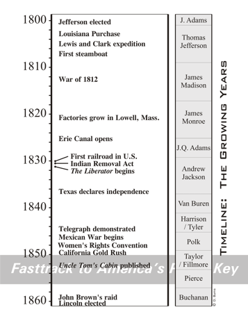 Page 93 |
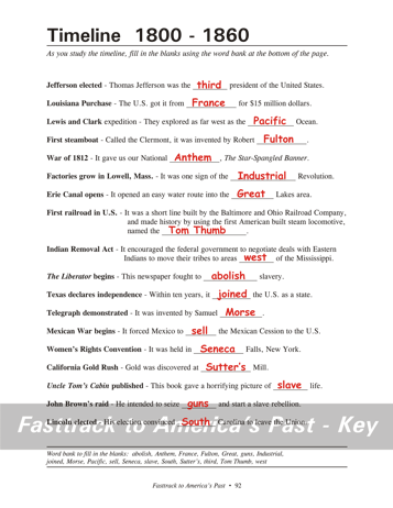
Pages 92
& 93 - Timeline
1800 - 1860 Review with students the layout and purpose of a timeline. Be sure students understand how the flow of time is shown in this visual format. The dates shown in the answer key below are for your reference, and students do not need to list them on their timeline or the timeline guide. Timeline event guide, page 92 To help study the timeline, students should complete the "fill in the blanks" event guide using the word bank at the bottom of the page. It's a good small group project, with students sharing what they already know, and then using a textbook, online encyclopedia, or other resources to help them pick the correct answers. 1. Jefferson elected - 1800 ...was the third president... 2. Louisiana Purchase - 1803 ...from France for $15 million... 3. Lewis and Clark expedition - 1804-06 ...as the Pacific Ocean. 4. First steamboat - 1807 ...by Robert Fulton. 5. War of 1812 - 1812 ...our National Anthem... 6. Factories grow in Lowell, Mass. - 1820s ...of the Industrial Revolution... 7. Erie Canal opens - 1825 ...into the Great Lakes area. 8. First railroad in U.S. - 1830 ...named the Tom Thumb. 9. Indian Removal Act - 1830 ...to areas west of the Mississippi. 10. The Liberator begins - 1831 ...fought to abolish slavery. 11. Texas declares independence - 1836 ...years, it joined the... 12. Telegraph demonstrated - 1844 ...invented by Samuel Morse. 13. Mexican War begins - 1846 ...Mexico to sell the Mexican Cession... 14. Women's Rights Convention - 1848 ...held in Seneca Falls, New York. 15. Calif. Gold Rush - 1849 ...discoverd at Sutter's Mill. 16. Uncle Tom's Cabin published - 1852 ...picture of slave life. 17. John Brown's raid - 1859 ...seize guns and start... 18. Lincoln elected - 1860 ...convinced South Carolina to leave... |
|
Copyright Notice
Copyright 2018 by David Burns. All rights reserved. Illustrations and reading selections appearing in this work are taken from sources in the public domain and from private collections used by permission. Sources include: the Dover Pictorial Archive, the Library of Congress, The National Archives, The Hart Publishing Co., Corel Corporation and its licensors, Nova Development Corporation and its licensors, and others. Maps were created or adapted by the author using reference maps from the United States Geological Survey and Cartesia Software. Please see the home page for this title for more information. |