 |
Fasttrack
to America's Past Teacher Key |
|
|
Fasttrack
to America's Past Teacher Key |
|
 Page 46 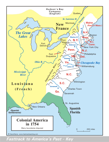 Page 47 The map is shown
as it appears when completed by students using color
pencils. The
full size map that students will use to guide their work can be found
with the link on the main index page for this section.
Please read the "Tips for completing the map" in the next column. |
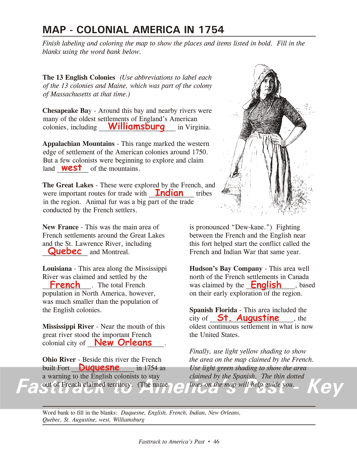
Pages 46
& 47 - Map - Colonial America in 1754 Map guide, page 46 Students should use the word bank at the bottom of the page as they work to complete the map guide's "fill in the blank" sentences. Chesapeake Bay - ... including Williamsburg in... Appalachian Mountains - ...land west of... The Great Lakes - ...with Indian tribes... New France - ...including Quebec and... Louisiana - ...by the French. Mississippi River - ...of New Orleans. Ohio River - ...Fort Duquesne in... Hudson's Bay Company - ...the English... Spanish Florida - ...of St. Augustine, the... The picture The drawing shows a Colonial era woman on a farm. Women were vitally important for their role in their families, and also for their role as producers in the economy of the colonies. Tips for completing the maps, page 47 Students should
work from the full size, completed map page shown with the link from
this
section's main
index page.
Emphasize neatness from the beginning! This map gives a snapshot of the colonies in 1754, the year the French and Indian War began. The shading shows the areas claimed by the French and the Spanish, as well as the area settled by the English. Be sure students understand that the English colonies had by far the largest population - many times that of the French or Spanish. The English also claimed the area west of the Appalachians. First, have students color the rivers with a dark blue pencil, staying carefully on the dotted lines.Next, have students work on their own, labeling the map features as they complete the paragraphs on the facing page. Urge them to use a #2 pencil or erasable ink pens for labeling. Color pencils are not very good for small lettering, and regular ink pens cannot be erased to fix a mistake. Have students shade, very lightly, the area claimed by France, using a yellow color pencil. Shade the Spanish areas lightly with green. The large bodies of water should be colored very lightly with a light blue color pencil. Point out that there was clearly going to be a conflict as the English colonists began spreading over the Appalachians. Fort Duquesne became the flash point in 1754 as the French and the English began the struggle for control of the region around the Ohio River. |
|
Copyright Notice
Copyright 2018 by David Burns. All rights reserved. Illustrations and reading selections appearing in this work are taken from sources in the public domain and from private collections used by permission. Sources include: the Dover Pictorial Archive, the Library of Congress, The National Archives, The Hart Publishing Co., Corel Corporation and its licensors, Nova Development Corporation and its licensors, and others. Maps were created or adapted by the author using reference maps from the United States Geological Survey and Cartesia Software. Please see the home page for this title for more information. |