 |
Fasttrack
to America's Past Teacher Key |
|
|
Fasttrack
to America's Past Teacher Key |
|
 Page 42 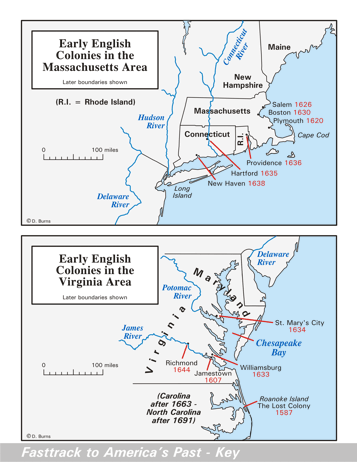 Page 43 The map is shown
as it appears when completed by students using color
pencils. The
full size map that students will use to guide their work can be found
with the link on the main index page for this section.
Please read the "Tips for completing the map" in the next column. |
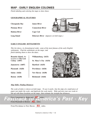
Pages 42
& 43 - Map - Early English Colonies Map guide, page 42 At the bottom of the page is a section titled Map Skills: Finding Distances. Show students how to mark the edge of a piece of paper or index card to match the scale. Once marked, the paper or card can be lined up with two points on the map to measure the straight line distance. Allow some variation, but the measured distance should be fairly close to these: From Jamestown to Richmond: 47
miles. The first drawing shows wooden buckets and a wooden butter churn for making butter from milk. Butter kept longer than milk without spoiling. The second drawing shows an early advertising image promoting tobacco from Virginia. Tobacco was the product that saved the colony financially and made it the wealthiest of the colonies in the Colonial era. Tips for completing the maps, page 43 Students should
work from the full size, completed map page shown with the link from
this
section's main
index page.
Emphasize neatness from the beginning! Ask students to notice the famous early
settlements on
the maps. Have them add the dates using a #2 pencil or erasable
red ink pen. (Color pencils are not good for small lettering, and
mistakes can't be fixed if students use regular ink pens.) |
|
Copyright Notice
Copyright 2018 by David Burns. All rights reserved. Illustrations and reading selections appearing in this work are taken from sources in the public domain and from private collections used by permission. Sources include: the Dover Pictorial Archive, the Library of Congress, The National Archives, The Hart Publishing Co., Corel Corporation and its licensors, Nova Development Corporation and its licensors, and others. Maps were created or adapted by the author using reference maps from the United States Geological Survey and Cartesia Software. Please see the home page for this title for more information. |