 |
Fasttrack
to America's Past Teacher Key |
|
|
Fasttrack
to America's Past Teacher Key |
|
 Page 26 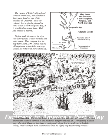 Page 27 |
Pages 26
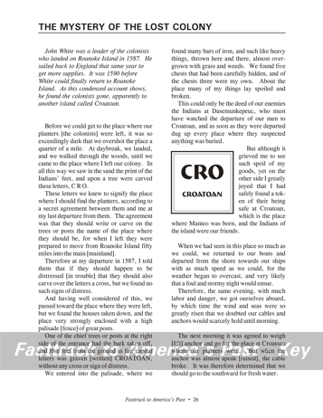
& 27 - The Mystery of the Lost Colony The reading selection, page 26 Before reading this selection, be sure students are familiar with the story of the Lost Colony. Orient them to the geography of the area with the maps on the facing page. Roanoke Island is about 3 by 5 miles, and sits just behind the long line of islands known as the Outer Banks of North Carolina. Croatoan was the name then for the lower part of Hatteras Island. Remind students that the account is over 400 years old, and uses language and phrasing common at the time of Shakespeare. To modern readers, the wording is a little awkward. Be sure students read the introduction to the reading carefully. John White, incidentally, was the grandfather of Virginia Dare, the first English child born in what is now the United States. Notice that the colonists had talked about moving off the island to the mainland even before John White left to get more supplies from England. That is one reason they agreed that they would leave a carved message if they did move before White returned.The Maps, page 27 Have students study the small map, and call their attention to the scale of miles. They should color the map, using light blue and green, to show the water and land areas. The map from 1590 that is shown at the bottom of the workbook page is surprisingly accurate, considering the state of navigation at the time. It is not, however, oriented with North at the top, as modern maps usually are. The sunken ships shown are a
reminder that the area around
the Outer Banks is notorious for shipwrecks. The map also shows
the
location of several Indian groups. Group Discussion
questions, page 27 These questions are tied to both the reading selection and the maps. John White is so sure the colonists had gone to Croatoan because he had made a specific agreement with them, before he left, about carving the name of their destination on a tree. Croatoan is about 50 miles from Roanoke Island, and White notes that an Indian there named Manteo was friends with the colonists. White believes the colonists were not in danger when they left because there is no cross carved over the word Croatoan on the tree trunk. That was the agreed-upon signal that would be used if the colonists had to leave their settlement under attack or other threat.A move to Croatoan would have offered at least two important advantages. It had Indians friendly to the colonists, and the Atlantic ocean was easily visible from there. As the years went by with no sign of White's return, the colonists, or some of their number, may have wanted to keep an eye out for any passing ship. |
|
Copyright Notice
Copyright 2018 by David Burns. All rights reserved. Illustrations and reading selections appearing in this work are taken from sources in the public domain and from private collections used by permission. Sources include: the Dover Pictorial Archive, the Library of Congress, The National Archives, The Hart Publishing Co., Corel Corporation and its licensors, Nova Development Corporation and its licensors, and others. Maps were created or adapted by the author using reference maps from the United States Geological Survey and Cartesia Software. Please see the home page for this title for more information. |