 |
Fasttrack
to America's Past Teacher Key |
|
|
Fasttrack
to America's Past Teacher Key |
|
 Page 18 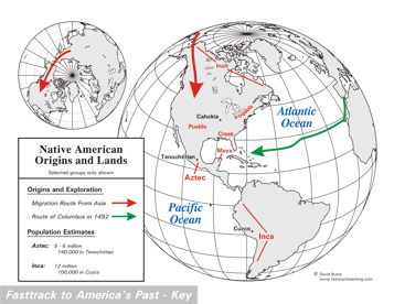 Page 19 The map is shown
as it appears when completed by students using color
pencils. The
full size map that students will use to guide their work can be found
with the link on the main index page for this section.
Please read the "Tips for completing the map" in the next column. |
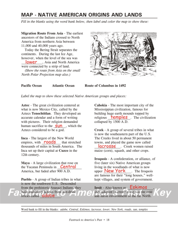
Pages 18
& 19 - Map - Native American Origins and Lands Map guide, page 18 Students should use the word bank at the bottom of the page as they work to complete the map guide's "fill in the blank" sentences. Migration Route From Asia - ...were lower, Asia and... Aztec - ...the sun, which the... Inca - ...with roads that stretched... Maya - ...Peninsula in Central America... Pueblo - ...bricks called adobe... Cahokia - ...topped by religious temples. Creek - ...game now called lacrosse. Iroquois - ...what is now upper New York. Inuit - ...known as Eskimos... The picture This very early drawing shows Native Americans of the mid-Atlantic coastal area cooking fish. Cooking over a smoking fire helped preserve the fish so they could be kept for months without going bad. Tips for completing the map, page 19 Students should work from the finished map shown with the link from this section's main index page. Emphasize neatness from the beginning! Start by having students draw, very lightly with a color pencil, the red arrows that show what many experts believe was the migration route of the ancestors of today's Native Americans. Once they have the line located correctly, they can darken it.Remind students that scientists are still not sure of the exact route. It is possible the path may have actually been along the shoreline of the land that once connected the continents when sea levels were lower, then down the shoreline of what is now Alaska and Canada. The time period when the crossing was made is also open to debate. Students should label the map, including the oceans, using a #2 pencil or erasable ink pens. Regular color pencils are not very good for small lettering, and a mistake made with regular ink pens can't be fixed. As they locate the selected Indian groups, be sure to mention that this is only a selection of the largest and most famous of the Indian groups. There were hundreds of others. Finally, have students draw the path of Columbus in 1492. Notice that he left Spain, sailed to the Canary Islands, then headed westward. The Canary Islands, incidentally, are not named for canaries, but for wild dogs living there (Latin: canines.) Experts disagree about which island was the first landing by Columbus in the New World. |
|
Copyright Notice
Copyright 2018 by David Burns. All rights reserved. Illustrations and reading selections appearing in this work are taken from sources in the public domain and from private collections used by permission. Sources include: the Dover Pictorial Archive, the Library of Congress, The National Archives, The Hart Publishing Co., Corel Corporation and its licensors, Nova Development Corporation and its licensors, and others. Maps were created or adapted by the author using reference maps from the United States Geological Survey and Cartesia Software. Please see the home page for this title for more information. |