 |
Fasttrack
to America's Past Teacher Key |
|
|
Fasttrack
to America's Past Teacher Key |
|
 Page 16 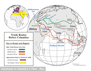 Page 17 The map is shown
as it appears when completed by students using color
pencils. The
full size map that students will use to guide their work can be found
with the link on the main index page for this section.
Please read the "Tips for completing the map" in the next column. |
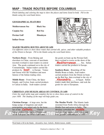
Pages 16
& 17 - Map - Trade Routes Before Columbus Map guide, page 16 Students should use the word bank at the bottom of the page as they work to complete the map guide's "fill in the blank" sentences. Northern Route - ...by boat to Europe. Middle Route - ...the Mediterranean Sea. Southern Route - ...city of Alexandria in... Christian Europe - ...the Catholic Church. The Muslim World - ...the middle sections... The picture This drawing made in Europe in the 1500s shows merchants making a trade or sale, perhaps involving products from the Far East. Tips for completing the map, page 17 Students should work from the full size, completed map shown with the link from this section's main index page. Emphasize neatness from the beginning! Ask students to
mark the routes on the map very lightly
with color pencils at first, so they can erase a mistake if necessary. The bodies of water should be labeled in the workbook with a regular #2 pencil or an erasable blue ink pen. Regular color pencils don't work very well for printing small letters, and a mistake made with regular ink pens can't be fixed. It is not necessary to color the seas, lakes, and oceans. Some students may want to do so, however, and that's fine as long as they use light blue, and shade very lightly.Finally, have students shade the small map as directed, using color pencils. Notice that the Muslim areas lay across the middle of the trade routes that are shown on the large map. |
|
Copyright Notice
Copyright 2018 by David Burns. All rights reserved. Illustrations and reading selections appearing in this work are taken from sources in the public domain and from private collections used by permission. Sources include: the Dover Pictorial Archive, the Library of Congress, The National Archives, The Hart Publishing Co., Corel Corporation and its licensors, Nova Development Corporation and its licensors, and others. Maps were created or adapted by the author using reference maps from the United States Geological Survey and Cartesia Software. Please see the home page for this title for more information. |